
Officials prepare for a potential landslide in Washington State, as four million cubic yards of rock slowly inch downhill
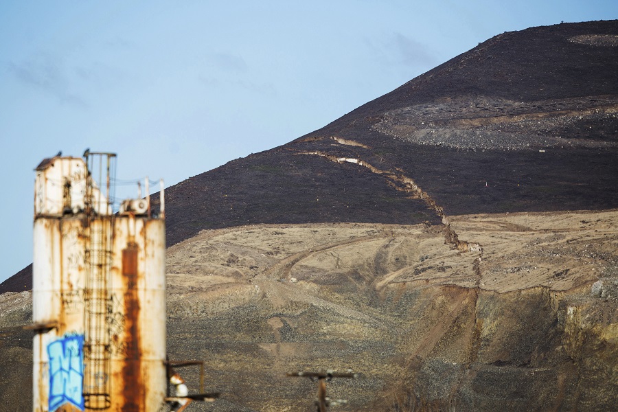
In south-central Washington State, a fissure located on Rattlesnake Ridge has put officials on alert as about four million cubic yards of volcanic rock continues to make a slow path downhill. Though the landmass is only moving at about two-and-a-half inches per day, local geological experts are keeping a close watch on the area, concerned that it could accelerate. Its proximity to a major connecting highway, large river, and a dam have officials concerned about the potential catastrophic effects if the slide breaks loose in a worst case scenario – though they have also emphasized that it is more likely the slide will slowly stabilize and come to rest at the base of the hill.
Unlike the recent mudslides in California that killed 21 in January of 2017, and the Oso landslide in Northern Washington that killed 43 in 2014, the Rattlesnake Ridge slide is not caused by water-saturated soil and erosion. Instead, the cause is predicted to be gravity, coupled with the presence of heavy basalt rock sliding over a slick sedimentary underlayer. Additionally, unlike in California and Northern Washington, officials have had time to prepare contingency plans since the landslide is forecasted to occur anywhere from late-February to early-April.
Seventy GPS monitoring stations, automated laser surveying stations, seismometers, and ground based radar instruments have been put in place by the Washington State Department of Natural Resources to watch the path and speed of the crack. This method has predicted the path and speed of slides in the past with surprising accuracy, despite the often changing state of a rock slide. In 2013, one of North America’s biggest nonvolcanic landslides occurred at Kennecott’s Bingham Canyon mine. Due to monitoring methods, not a single casualty occurred, as officials were able to evacuate the site the morning prior to the slide.
By January 22, 74 people living near Rattlesnake Ridge had been evacuated indefinitely from the area. The gravel quarry located directly under the hill was closed, and the company that owns it has voluntarily offered to pay for the lodging of the evacuees in nearby hotels for five weeks. A road running along the bottom of the hillside has been closed, and auxiliary highway routes have been planned, in case the interstate becomes blocked due to the slide. If the river also becomes blocked, irrigation canal operators are ready to remove water and open dams.
Luckily, that outcome looks less likely.
“The geologic foot is coming off the gas,” David Montgomery, a geomorphologist at the University of Washington told the Seattle Times. “Even though it’s moving faster than it was, the rate of acceleration is declining.” Even with these measurements and predictions, though, it is difficult to accurately predict the exact path of a slide, which is why the local government has decided to err on the side of caution.
In comments made to the New York Times, Arlene Fisher-Maurer, city manager of Union Gap, a small community just north of Rattlesnake Ridge, describes this preparation as “key,” and says she believes that “it’s going to do us well.”
Sources and further reading:
Watching a Ridge Slide in Slow Motion, a Town Braces for Disaster –New York Times
Body of mother found after California mudslide, death toll rises to 21 –NBC News
Dozens Evacuate In Washington State, Fearing Landslide – NPR
Landslide watch: Can experts predict collapse at Washington’s Rattlesnake Ridge? – The Seattle Times
The Rattlesnake Ridge – A Landslide In The Making – Forbes
Sizing up the Landslide at Bingham Canyon Mine – NASA Earth Observatory