
New Extreme Weather Data
“Two Issues are lack of routinely available data that’s useful at the local scale and experts who can translate science-based findings into policy objectives. We simply don’t have that cadre built yet of knowledgeable people who can consult and offer advice.”
As confirmed during Phase 1 of the Region 1 Electric Energy RRAP there is an ongoing need for useable data regarding increased extreme weather events. The following resources are provided to State and private sector organizations for use in their analysis:
Extreme Weather, Heat and Precipitation Data Layers
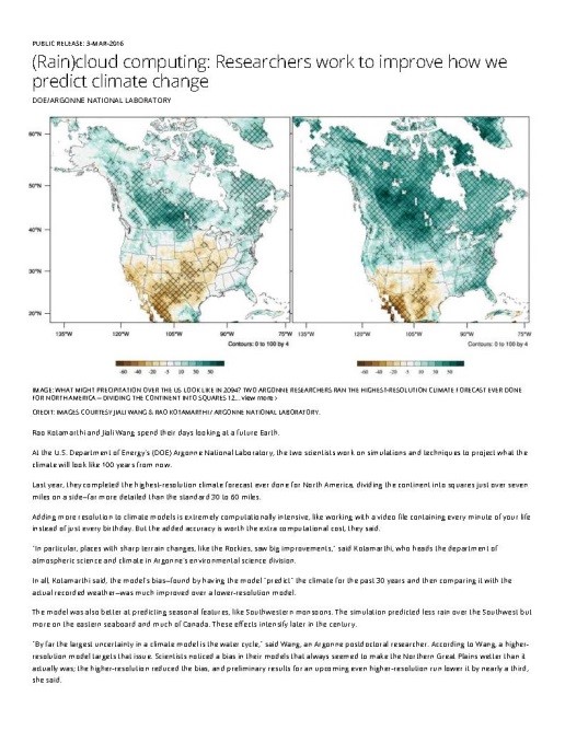
Argonne National Laboratory (Argonne) climate scientists have recently completed the highest-resolution, dynamically-downscaled climate projection ever done for North America, dividing the continent into grid-squares just over seven miles on a side – far more detailed than global climate models that use 30 to 60 mile grid squares. Click on the image to the right to access a paper about the data.Argonne has provided downscaled climate modeling data for RRAP project stakeholders and the public for use in broader adaptation planning and preparedness applications. Using the dynamically downscaled climate model outputs, Argonne generated a series of temperature and precipitation projections for the RRAP Region 1 study area using the RCP8.5 (high) emission scenario. The following figures show the GIS-generated data layers derived from the climate model outputs available for Region 1. For additional information on the data and it potential uses see Maine User Manual and Maine RRAP Report.
For details on the data available contact:
Dr. V. Rao Kotamarthi, vrkotamarthi@anl.gov, (630) 252-7164 or
Jiali Wang, jialiwang@anl.gov, (630) 252-2848
Illustrated Extreme Weather Projections
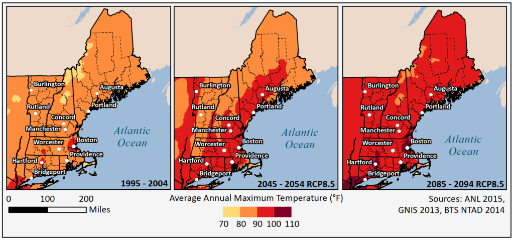
Figure 1 displays the historic and projected average annual maximum temperature for both mid-century and end-of-century decades under a high emission scenario (RCP8.5), as compared with recent historical trends. These values constitute the maximum recorded temperatures across the region within 1 year, averaged across each of the three 10-year evaluation time-periods (e.g., 1995-2004). Region 1 could regularly experience average annual maximum temperatures ranging from 90 to 95 degrees Fahrenheit by the middle of the century, and up to 100 degrees Fahrenheit by the end of the century; some areas near major urban centers in the southern portion of the region may regularly experience annual maximum temperatures between 100 and 110 degrees Fahrenheit by the end of the century.
Download Data Layer – Average Annual Maximum Temperature 1995 – 2004
Download Data Layer – Projected Average Annual Maximum Temperature 2045 – 2054
Download Data Layer – Projected Average Annual Maximum Temperature 2085 – 2094
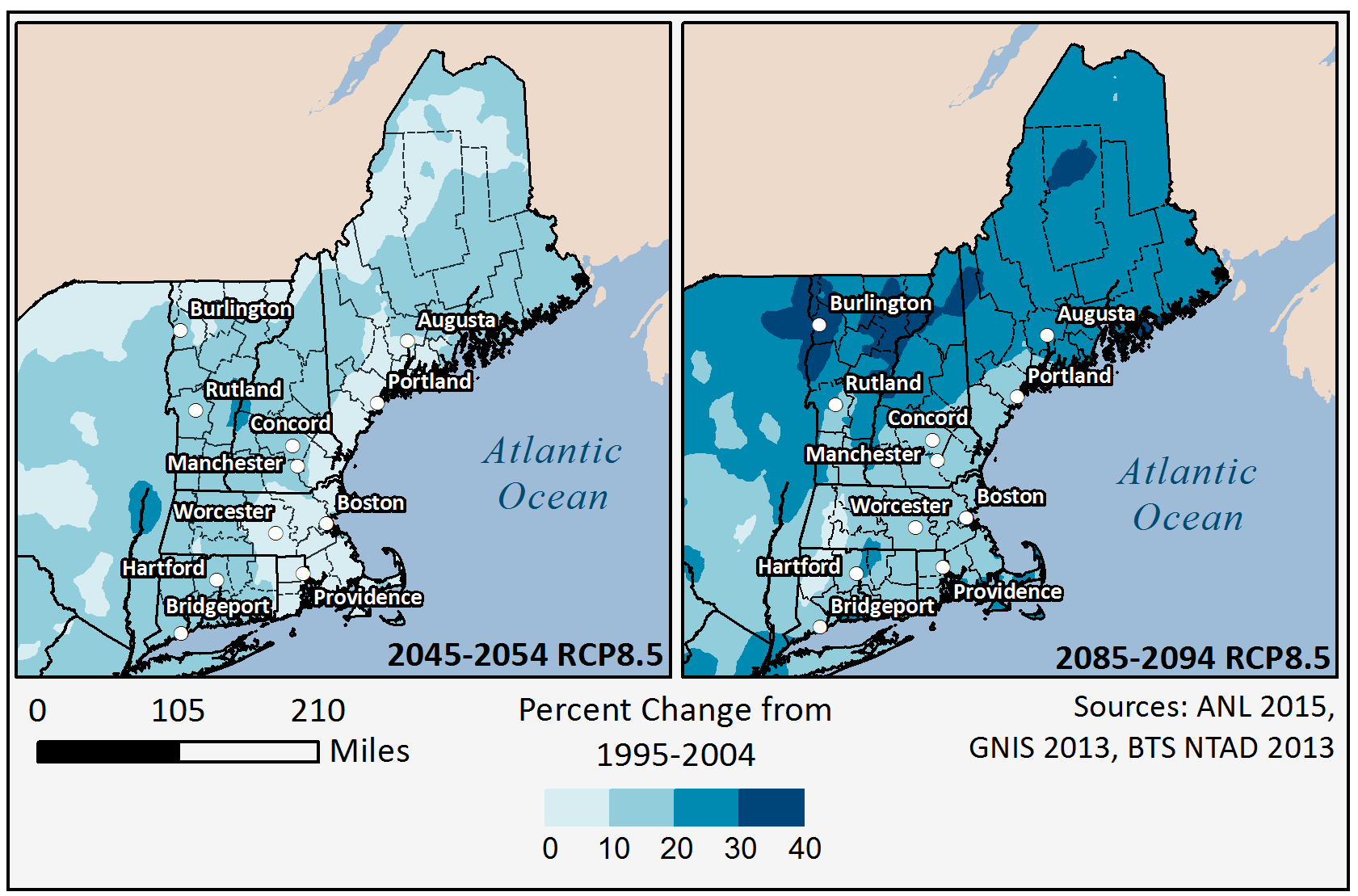
Projected Percentage Changes in Average Daily Precipitation Amount in Region 1
Download Data Layer – Projected Average Daily Precipitation Change 2045-2054
Download Data Layer – Projected Average Daily Precipitation Change 2085-2094
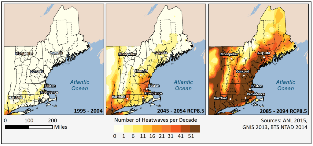
Figure 3 shows projected changes in the number of heat waves for future decades across the Region. A heat wave is defined here as two consecutive days with peak temperatures above 90°F. Although increases in heat waves are not widespread by mid-century, a significant increase in the frequency of heat waves is projected by the end of the century across the Region. By end of the century in some areas there could be as many as 300 heat waves per decade. The trends may suggest that in areas where the projected heat wave frequency is particularly high, prolonged periods could occur where temperatures remain above 90°F which is consistent with the projected changes in average annual maximum temperature shown in Figure 1.
Download Data Layer – Actual Heatwaves 1995-2004
Download Data Layer – Projected Heatwave per Decade 2045-2054
Download Data Layer – Projected Heatwave per Decade 2085-2094
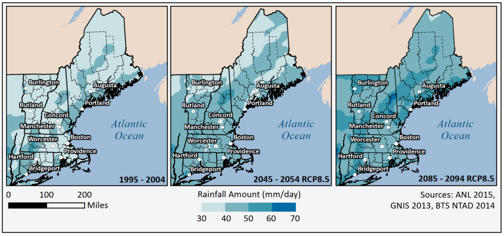
Figure 4 shows the rainfall amount for the greatest daily precipitation events (> 99th percentile) under the RCP8.5 (high) scenario. That is, the amount of precipitation falling in one day for the heaviest 1% (99th percentile) of precipitation days on an annualized basis for a historical and future 10 year timeframes. Note that while some heavy precipitation increases are projected across the Region by mid-century, these increases will become more widespread by the end of the century.
Download Data Layer –Maximum Daily Precipitation 1995-2004
Download Data Layer – Projected Maximum Daily Precipitation 2045-2054
Download Data Layer – Projected Maximum Daily Precipitation 2085-2094
Storm Surge Combined with Sea Level Rise Data

Geospatial hazard data layers generated by staff at Oak Ridge National Laboratory were used during Phase 1 of the 2016 DHS Region 1 RRAP to identify substations which could be impacted by a Cat 3 hurricane scenario combined with a 2050 sea level rise of 25cm (9.8 inches). With permission of Benjamin Preston these data layers are provided here for download and use. The data layers were constructed from archived simulations of the Sea, Lake and Overland Surges from Hurricanes (SLOSH) model from the National Hurricane Center of the National Oceanic and Atmospheric Association (NOAA), the National Elevation Dataset (NED) tiles, and projected SLR values at Mean Higher High Water (MHHW) to produce an interpolated inundation surface. Click on the image to the right to access the complete paper for details about the data and case study.
For more information about the data and process contact:
Dr. Benjamin Preston, bpreston@rand.org, (310) 393-0411, ext. 7481