
Potential superstorms highlight vulnerability of Boston’s food supply
In the city of Chelsea, a suburb north of Boston, one of New England’s most critical food facilities lies in a flood zone. Along with Massachusetts General Hospital facilities, a substation and an MBTA stop, the New England Produce Center (NEPC) rests just along the Mystic River in an area that was once marshland, and is at risk of being reclaimed by the river in the event of a major storm.
The NEPC distributes produce to 8 million people in the northeast, reaching as far as Canada. With four buildings and thousands of employees, the NEPC is the third largest food distribution center in the country. If the Boston area is hit with a Hurricane Sandy-level storm at high tide, it may mean trouble for the NEPC: its main access road and the train tracks used to bring in produce would be underwater, halting distribution and forcing multiple days of lost business.
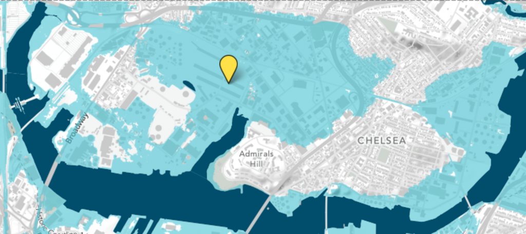
Though the structure of the building is made of “heavy, impermeable concrete”, if the NEPC becomes flooded, the physical facility will not be particularly conducive to draining water. Power stations throughout the city are also expected to be affected, and loss of power also has the potential to slow the NEPC’s recovery time. A storm affecting operability would disrupt regional food supply, leading to shortages and increased prices, and the shutdown of the distribution center would render its thousands of staff unemployed. As a major job provider in the primarily low-to-middle income city of Chelsea, even a short term disruption in NEPC employment could have a lasting effect on Chelsea families.

Earlier this year, heavy rainfall flooded nearby streets, reiterating the need for flooding prevention measures in Chelsea. A report by the city of Chelsea details plans to invest in green infrastructure, specifically a living shoreline that will grow with sea level rise, and gray infrastructure such as retaining walls for mitigation of sea level rise and future flooding. The city plans on using public-private partnerships to fund risk mitigation in the area, including the rehabilitation of marshland to enhance water absorption, in early 2018.
More area towns and cities might follow suit as the impacts of climate change continue to become more apparent in communities across the northeast, creating disruptions in supply chains, reshaping the coastline, and requiring investment and mitigation.
Additional Reading
How a Bad Storm Could Endanger New England’s Food Supply – WBUR
Designing Coastal Community Infrastructure for Climate Change – City of Chelsea, Massachusetts
Two-year-old rescued from car on flooded street in Chelsea – The Boston Globe
Climate change will hit New England hard, report says – The Boston Globe
Using Green Infrastructure in the City of Chelsea – City of Chelsea, Massachusetts
Additional Green Infrastructure Heads to Chelsea – Mystic River Watershed Association
Sea Change – Sasaki Institute